Oak Harbor is proposing extensive mitigation measures as part of an application for dredging the city-owned marina.
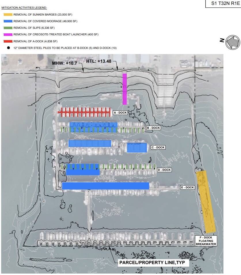
Proposed mitigation may include the removal of marina structures, including A dock, covered moorage roofing and support structures, sunken barges, an unused boat launcher and finger floats, according to a public notice from the Army Corps of Engineers. Such mitigation measures, which would take place over 10 years, are meant to balance out any environmental harm caused by dredging and are a regular part of permitting for in-water projects.
The Army Corps of Engineers is accepting comments about the project at rrs.usace.army.mil/rrs.
City officials are in discussions about how best to fund dredging as well as other improvements at the Oak Harbor Marina. Ideas have included the adoption of a business and occupation tax on the top-earning businesses, the creation of a port district, the expansion of an existing port district and the formation of a metropolitan parks and recreation district.
The officials have made it clear that regular dredging of the marina is necessary for boat traffic. A city consultant reported that dredging is needed every 10 to 13 years, City Councilmember Eric Marshall said at a meeting. The cost of dredging is estimated at $10 million, while the city already has a $1 million grant from Island County.
The Army Corps of Engineers notice states that the city is proposing to dredge a total volume of 180,000 cubic yards over 960,000 square feet within the marina. The dredging would occur within previously dredged areas and would be permitted for a 10-year period, with possible phasing.
“Contingent on obtaining funding for the project, key areas within the marina may be prioritized and phased if funding is not secured to complete all proposed dredging in a given year,” the notice states.
The proposed work would dredge 10 feet to 15 feet below “mean lower low water,” which is the average height of the lowest tide. The work would be done using hydraulic or mechanical dredging.
The proposal is to dispose of the dredging material at both the Port Gardner non-dispersive disposal site near Everett and the Rosario Strait dispersive disposal site.
The notice explains that the city chose not to complete testing of the sediment to be dredged prior to the public notice being published, but it must be tested before the review is complete. The Dredged Material Management Program will evaluate whether the material can be disposed of in the water or whether it will need to be placed at an upland location.
Dredging in sensitive aquatic areas often requires extensive environmental mitigation because of negative impacts on underwater habitat for animals and plants as well as the possible release of contaminants from sediments, according to the Army Corps of Engineers.
Much of the proposed mitigation at the marina would remove creosote-treated wood structures. The state Department of Natural Resources’ Creosote Removal Program has been working since 2007 to reduce the source of the toxic chemical from Puget Sound. Creosote-treated pilings may leach chemicals into the sediment and water column throughout their lifetime, according to the DNR. Studies have shown, for example, that creosote causes high mortality in herring eggs, which are an important forage fish and critical to the health of salmon — and therefore southern resident orcas.
The boat launcher, which is no longer in use, has 26 creosote-treated piles and 1,550-square-feet of creosote-treated wood that would be removed under the proposal.
The notice states that nearly 5,000 square feet of A dock floats would be removed, including eight creosote treated piles. In addition, finger floats from B dock to D dock would be removed along with associated creosote-treated piles.
Finger floats from B and D docks may be removed along with 16 creosote-treated piles.
The sunken barges would be removed with a barge-mounted crane or excavator, while a debris boom would be installed prior to the work.
Some of the proposed mitigation would eliminate structures that cause shading. The DNR discourages moorage structures that may shade aquatic habitats, according to its website.
The Army Corps of Engineers report states that the dredging mitigation may include the removal of moorage roofing and support structures from B, C, D and E docks. That amounts to 67,000 square feet of covered moorage.
The notice explains that the mitigation activities would be completed in segments or may not be completed if all the proposed dredging does not occur.
The notice states that the area may contain cultural resources and that the Corps has sent notice to tribal governments about the project.
The notice explains that any person may request a public hearing.
In considering the permit, the Corps will look at a variety of factors, including conservation, economics, aesthetics, general environmental concerns, historic properties, fish and wildlife values, flood hazards, floodplain values, land use, navigation, shoreline erosion and accretion, recreation, water quality, safety, considerations of property ownership and, in general, the needs and welfare of the people.
“The decision whether to issue a permit will be based on an evaluation of probable impacts, including cumulative impacts, of the proposed activity on the public interest,” the notice states. “That decision will reflect national concern for both protection and utilization of important resources. Benefits that may be reasonably expected to accrue from the proposal, must be balanced against its reasonably foreseeable detriments.”